Mapping the Future: How the Geospatial Industry Is Quietly Becoming India's Next Big Thing
BY
Shuchi Nahar
Industry Trends
Engineering Sector
Imagine a world where every decision—whether it's building a highway, predicting floods, planting crops, or planning smart cities—is driven by precise location data. This scenario is no longer science fiction, it is the reality of Geospatial Technology, and it is developing right before our eyes.
For decades, geospatial data remained a behind-the-scenes resource, primarily utilized by governments, scientists, and defense agencies. However, thanks to recent policy changes, innovative entrepreneurs, and advancements in digital infrastructure, this industry is now poised to take center stage. We are just at the basecamp of a mountain, and the view from the top promises to be spectacular.
Let’s understand what’s happening – and why companies like Ceinsys Tech and Genesys International could become household names in the next few years. There are industries that grow quietly in the background and then—boom—they're everywhere. Think of IT in the '90s or digital payments post-2016. Now, imagine a sunrise industry that has the potential to silently revolutionize how governments plan, how cities grow, and how businesses deliver services more efficiently. That industry is Geospatial Technology. And if you haven’t paid attention yet—this is your cue.
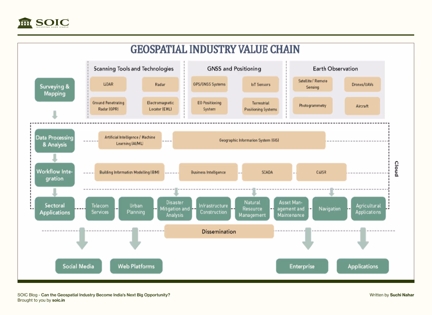
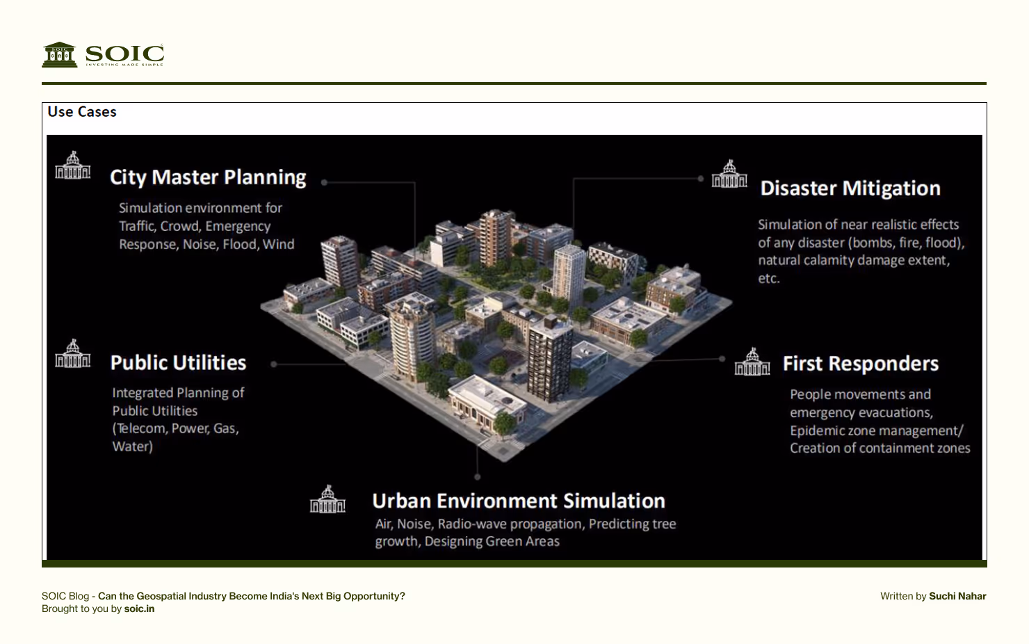
The final stage involves applying this intelligence across sectors like urban planning, infrastructure, agriculture, disaster management, and smart cities. Companies operating across the entire chain—like Ceinsys and Genesys—gain a competitive edge by offering end-to-end solutions, from map creation to real-time decision-making tools.
Why Geospatial Matters: From Maps to Mega Missions
At its core, geospatial technology is about turning location into intelligence. But this isn't just about Google Maps anymore. It’s about 3D mapping, real-time data from satellites, drones, IoT sensors, and AI-powered decision-making that shapes:
Smart cities
Faster crop cycles in agriculture
Optimized transport and logistics
Railways, roads, ports, 5G networks
Climate resilience and disaster management
Even your property tax collection!
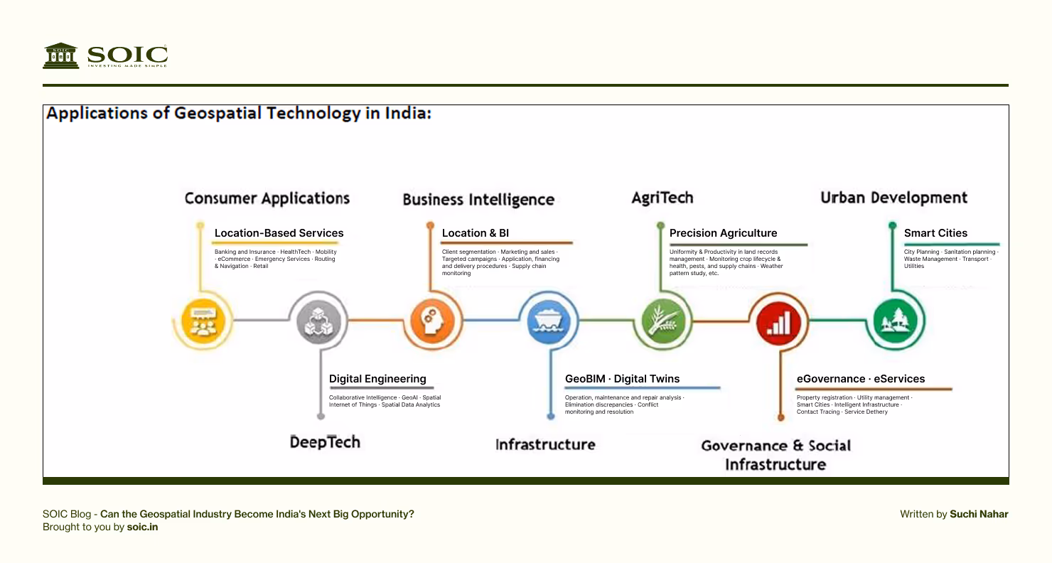
From urban governance dashboards under the Smart Cities Mission to property validation under SVAMITVA, India’s digital development is now deeply rooted in geospatial infrastructure.
With national programs like PM Gati Shakti, Digital India Land Records, and AMRUT, the application is only going to deepen. This is not a passing trend—it's becoming the very fabric of India’s growth blueprint.
Big Numbers, Bigger Vision
According to industry estimates, India’s geospatial economy—currently valued at ₹29,000 crore in FY24—is expected to grow to over ₹ 1 trillion by FY30, achieving a compound annual growth rate (CAGR) of approximately 22%. This growth rate outpaces many traditional tech sectors and underscores how location intelligence is fast becoming a national economic pillar.
Why this explosive growth? Three powerful tailwinds
Progressive Policy Reforms – Like the Geospatial Data Guidelines 2021 and National Geospatial Policy 2022.
Homegrown Data Sovereignty Push – The government is actively restricting foreign players, creating room for Indian companies.
Cross-Sector Demand Explosion – Logistics, urban planning, agriculture, telecom, healthcare—all now powered by location data.
Ceinsys Tech – The Smart Engineering Brain
A part of the ALTAIR Group, Ceinsys has built deep expertise in GIS, remote sensing, and engineering consultancy. It works closely with government and infrastructure clients across water, transport, and utilities.
Ceinsys is not just a GIS player—it’s an engineering powerhouse offering value-added consulting across urban, industrial, and public sectors.
Decades of Expertise: Trusted advisor for multiple government contracts.
4.5x Order Book Visibility: Selective bidding with a 90%+ win rate!
Strategic Acquisitions: Recent Allygrow buyout pushes them into automotive, industrial automation, and telecom—new geospatial frontiers.
International Footprint: Expansion into US markets signals global ambition.
What makes Ceinsys unique:
Long-standing experience with urban and rural development authorities.
Uses AI-powered geospatial analytics to optimize infrastructure planning.
Deep focus on water supply, sewerage mapping, and smart energy grids.
Active in international projects – bringing credibility and scale.
Robust Order Book:
₹1,210 crore order book (4.5x FY24 revenue) with 90% bid success rate.
Execution visibility for 2+ years with additional ₹500 crore pipeline.
Inorganic Growth via Acquisitions:
Acquired AllyGrow Technologies (automotive & industrial automation) and a US-based telecom-focused GIS business.
New marquee clients like Ericsson and Mastek added.
Diversified & Scalable Business:
59% revenue from geospatial & engineering services, 41% from technology (100% international).
Expanding into AI/ML, IoT, and Industry 4.0, keeping it agile and future-ready.
Strong Financial Growth Outlook: (just an estimate)
Revenue - 60%, EBITDA - 64%, EPS 35% expected to grow at CAGR over FY25–27.
Valued at 35x FY27 P/E, with margin expansion from operating leverage.
In a world where infrastructure must be both smart and sustainable, Ceinsys sits right at the intersection.
Think of Ceinsys as the company laying invisible foundations for cities of the future.
Genesys International – The Digital Twin Master
If Ceinsys is the consulting brain, Genesys is the tech soul. They’ve already made a mark on international projects and are leaders in 3D digital mapping, one of the highest-growth sub-segments.
Pioneering 3D Digital Twins:
Critical for smart infrastructure and urban planning.
Tech + Partnership Muscle: Collaborations with Survey of India, GEOSA, Google, and automotive clients like NNG. Automobile + Enterprise Tech: Expanding deeply into OEMs, electric mobility, and in-car navigation systems.
Its biggest bet? India’s first 3D digital map platform – IndiaMap
This isn’t your regular Google Maps. IndiaMap is a high-resolution, LIDAR- and drone-powered representation of India’s top cities, built to support:
Autonomous vehicles
Urban planning
Infrastructure monitoring
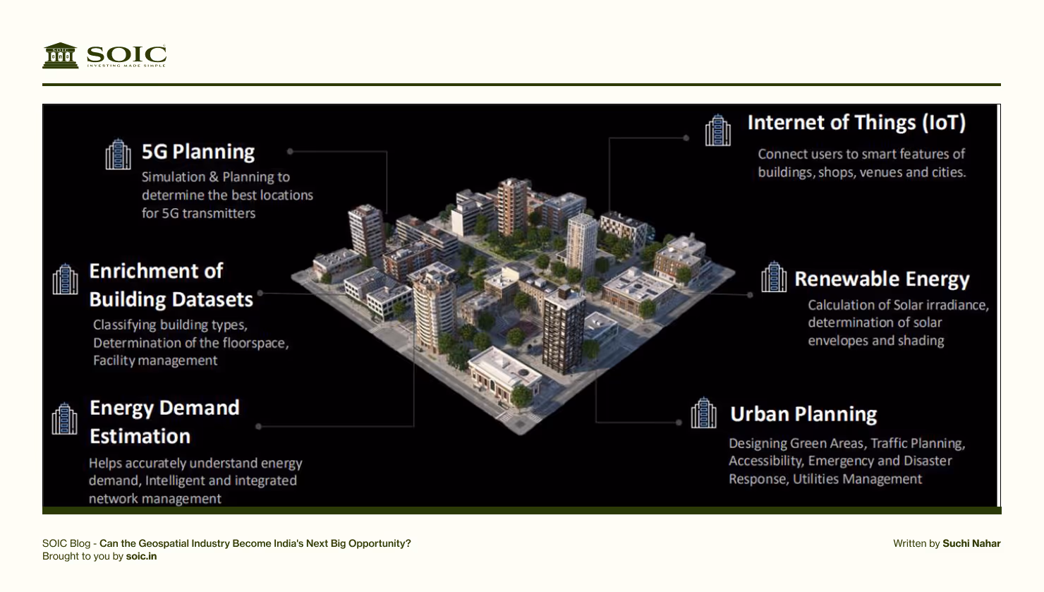
Telecom and 5G rollouts
Disaster management
Genesys has also collaborated with ISRO, Survey of India, and various municipal bodies to create nationwide digital twins. Their model is scalable – a potential moat.
Leadership in 3D Mapping & Digital Twins:
Flagship platform Oyster 3D with 5 cm accuracy.
Executed major projects like Mecca 3D, Mumbai 3D, and Pune smart city model
Strong Order Book & Pipeline:
₹500 crore order book with ₹2,400 crore pipeline and 40% win rate expected.
Focus on government, infrastructure, and enterprise use-cases.
Global & Automotive Expansion:
Serving Google, Microsoft, BMC, Apple, and expanding into ADAS, automotive mapping.
Looking to compete with incumbents like C.E. Infosystems in vehicle navigation.
Explosive Earnings Potential: (just an estimate)
Revenue 52%, EBITDA54%, EPS 72% expected to grow at CAGR over FY25–27.
Valued at 35x FY27 P/E, supported by strong tech, partnerships, and global execution capability.
In a future where cities are simulated before they’re built, Genesys could be the simulator-in-chief.
Geospatial – Let’s bring this closer to home (Use-Cases You Can Relate To).
E-commerce Delivery: Every time you track your package or find a nearby seller—geospatial.
Precision Farming: Farmers now use remote sensing to boost yield and save water.
Pandemic Management: Geospatial tools were crucial in COVID zone mapping and hospital resource allocation.
Your Land Records: SVAMITVA uses drones and GIS to give villagers digital property cards.
These aren't distant ideas—they’re reshaping our everyday life.
Sector-Level Variables:
Government Policy & Budget Allocation - Implementation of National Geospatial Policy, Gati Shakti, Smart Cities Mission, etc. Capex in digital infrastructure and public utilities.
Technology Adoption Trends - Uptake of 3D mapping, digital twins, AI/ML, IoT in geospatial use-cases.
Private Sector Adoption - Increased enterprise use in logistics, telecom, automotive, and agriculture.
Regulatory Landscape -Data localization, foreign player restrictions, open access norms.
Global Demand & Export Opportunities - Overseas contracts in mapping, consulting, or satellite data analytics.
Company-Level Variables:
Order Book Size & Visibility - Current backlog vs. annual revenue (e.g., 4.5x revenue = high visibility).
Win Rate in Bidding - Especially for government or international contracts (~90% for Ceinsys).
Revenue Growth & Segment Mix - Watch for share of high-margin international and 3D mapping revenue.
EBITDA Margins - Margin expansion via operating leverage and project scale (watch synergy gains post-acquisitions).
Inorganic Growth Moves - Acquisitions in new geographies or sectors (e.g., telecom, auto, AI).
Client Base & Repeat Business - Marquee clients like Google, Microsoft, BMC indicate strong tech IP.
Technology Moat - Proprietary platforms like Genesys’ Oyster 3D, use of LiDAR, AR/VR integration, etc.
Roadmap for National Geospatial Policy, 2022:
Vision: Position India as a global leader in the geospatial sector with an innovation-driven ecosystem, fostering a thriving geospatial industry, and democratizing data access for national development and citizen services.
Milestones:
By 2025
Establish a policy and legal framework to liberalize the geospatial sector and enhance commercialization.
Improve access to high-quality location data to spur innovation and enterprise.
Create an integrated interface for easy sharing and reuse of location-based digital data developed using public funds.
Redefine the National Geodetic Framework with modern positioning technologies and online access.
Achieve a high-accuracy geoid for the entire country.
Strengthening geospatial management structures at national and sub-national levels with multi-stakeholder participation.
By 2030
Conduct high-resolution topographical surveys (5–10 cm for urban/rural and 50–100 cm for forests/wastelands).
Develop a high-accuracy Digital Elevation Model (DEM) (25 cm for plains, 1–3 m for hilly areas).
Establish a Geospatial Knowledge Infrastructure (GKI) with an integrated data and information framework.
Build enhanced capabilities and awareness to meet evolving geospatial needs.
By 2035
Develop high-resolution bathymetric geospatial data for inland waters and sea surface topography to support the Blue Economy.
Map subsurface infrastructure in major cities and towns.
Create a National Digital Twin for major urban centers to enhance planning and management.
Risks to Watch – Every story has its cautions:
Policy changes or dilution of domestic protection.
Slower-than-expected government capex.
Disruption from new tech or global competitors.
But with the current pace of execution and India’s push for self-reliant digital infrastructure, the long-term risk-reward looks favourable.
I still remember using the old foldable maps on road trips with my family. You’d spread them across the dashboard, argue over routes, and trust your gut. Today, a voice from your phone guides you through every turn – thanks to geospatial tech.
Now imagine that same guidance – but for governments, for cities, for climate policy, and for entire industries. That’s where the world is heading. The geospatial industry may not make flashy headlines yet. But it is building the foundation for a better, more efficient, and more connected tomorrow.
Disclaimer:
The information provided in this reference is for educational purposes only and should not be considered investment advice or a recommendation. As an educational organization, our objective is to provide general knowledge and understanding of investment concepts. We are SEBI-registered research analysts.
It is recommended that you conduct your own research and analysis before making any investment decisions. We believe that investment decisions should be based on personal conviction and not borrowed from external sources. Therefore, we do not assume any liability or responsibility for any investment decisions made based on the information provided in this reference.
Industry Trends
Engineering Sector
Market Trends
Sector Analysis
Author
Shuchi Nahar
Masters in Finance with 5 years of industry experience. My approach is to take one sector at a time and explore plausible Investment ideas.


%20(1).png)

0 Comments